
South Fork Peachtree Creek runs through Clarkston, and NOAA keeps a stream gauge on it at Casa Drive. The stages it publishes say a lot about when creek water starts to matter for a house.
Key takeaways
- NOAA lists flood stage at the Casa Drive gauge as 10 feet, moderate flooding at 15 feet and major flooding at 19 feet.
- The highest crest on the gauge's record is 10.25 feet, reached on September 27, 2024.
- At moderate flooding, NOAA says water reaches the foundations of some homes on Casa Woods Lane and Casa Drive.
- Creek water carries sediment and contamination, so it is handled as a sanitation job, not just a wet floor.
- Porous materials touched by creek water, such as carpet, pad and insulation, usually cannot be saved.
What the Casa Drive gauge tells a homeowner
South Fork Peachtree Creek runs through Clarkston. NOAA operates a stream gauge named South Fork Peachtree Creek at Casa Drive at Clarkston.
A gauge reads in feet of creek height, and each stage has a plain meaning for the neighborhood around it.
- Flood stage: 10 feet, the point where the creek is considered to be flooding.
- Moderate flooding: 15 feet, when NOAA says water reaches the foundations of some homes on Casa Woods Lane and Casa Drive.
- Major flooding: 19 feet, when water covers Casa Drive at the bridge.
Where recent crests have landed
NOAA lists the highest recorded crest at the Clarkston gauge as 10.25 feet on September 27, 2024. That was just past flood stage, and well below the moderate level.
Other listed crests are 9.79 feet in October 2020, 9.35 feet in August 2013 and 8.59 feet in December 2018.
None of those reached moderate flooding. Still, a crest near 10 feet means the creek is full and running at the edge of its banks.
Why near flood stage still matters
Water does not have to reach a foundation to cause trouble. Heavy rain can send runoff off asphalt and concrete faster than the ground absorbs it.
The City of Clarkston runs its own stormwater management program and notes that runoff from paved surfaces can cause flooding and erosion.
Rain ahead of the creek
Before Hurricane Helene in September 2024, the city warned of 8 to 12 inches of rain across North and Central Georgia, including metro Atlanta.
The same month, the gauge logged its highest crest. Warnings like that are worth taking seriously for any home near a creek.
Creek water is not clean water
Water from a creek or storm runoff is classed as contaminated. It carries soil, debris, oil and whatever else the stream picked up on the way.
That is different from a supply pipe leak, where the water starts clean. The cleanup standard is stricter for creek water because of what is in it.
- Carpet and pad that creek water touched are usually removed and discarded.
- Insulation in wet wall cavities is replaced rather than dried.
- Drywall wicks water upward, so the cut is made above the visible water mark.
- Hard surfaces such as concrete and tile are cleaned and sanitized, then dried.
- Children, pets and anyone with a weak immune system should stay out of affected rooms.
The first steps when the creek is rising
Safety is first. Do not walk or drive through moving water, and keep out of a flooded room until the power to it is off.
Water covering Casa Drive at the bridge is one example of a road that can turn dangerous quickly.
Before water arrives
- Move valuables, papers and electronics to upper shelves or an upper floor.
- Shut off power at the panel if water is expected to reach outlets and it is safe to reach the panel.
- Photograph rooms, furniture and appliances for a claim.
After water arrives
- Wear boots and gloves, and keep skin away from the water.
- Do not use household fans or a standard vacuum on standing creek water.
- Call for extraction rather than waiting for the creek to fall on its own.
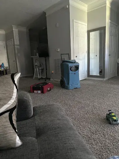
How the crew removes and dries after a creek flood
Standing water goes first. The extraction crew uses pumps and extractors to pull it from floors, and every hour that water stays, it moves further into subfloor and drywall.
Then the drying team marks where moisture is with meters and a thermal camera, removes materials that cannot be cleaned, and sanitizes what stays.
Drying to a reading
Air movers and dehumidifiers run until readings in the framing and subfloor match a dry reference. Looking dry is not enough.
The drying time estimator shows how room size and wetness affect the timeline.
Records for insurance
Photos, moisture readings and a list of removed materials make a flood claim easier to assess. Flood coverage often sits in a separate policy, so the documents matter.
Parks, floodplain and what sits near the water
A draft city plan said about 1.25 acres of Clarkston lie in the 100 year flood plain, and that area runs through Milam Park. No 500 year flood plain lies inside the city limits.
That is a small mapped area. Even so, a home outside the mapped floodplain can still take on water from a blocked drain or a sudden downpour.
Clarkston's apartment communities, parks and commercial corridors sit close to its creeks and storm drains. A resident of any of them can ask the property manager how water has behaved there before.
- Check the property against the mapped floodplain before buying flood insurance.
- Keep gutters and yard drains clear of leaves.
- Know which rooms sit lowest so valuables stay out of them in a storm.
Where to find help in Clarkston
The Clarkston water damage page lists every service available there. For creek or storm water in a home, the pages on storm and flood cleanup in Clarkston and water extraction in Clarkston describe the process step by step.
A broader overview of storm water cleanup is on the page for storm and flash flood cleanup.
Questions
At what height does South Fork Peachtree Creek flood in Clarkston?
NOAA lists flood stage at the Casa Drive gauge as 10 feet. Moderate flooding begins at 15 feet and major flooding at 19 feet.
What was the highest crest recorded at the Clarkston gauge?
NOAA lists 10.25 feet on September 27, 2024 as the highest recorded crest. Other listed crests are 9.79 feet in October 2020, 9.35 feet in August 2013 and 8.59 feet in December 2018.
Why is creek water handled differently from a pipe leak?
Creek water picks up sediment, debris and contamination. Materials it touches, like carpet and insulation, are usually removed, and surfaces that stay are cleaned and sanitized before drying.
Can a home outside the mapped floodplain still flood?
Yes. Heavy rain on paved surfaces and clogged drains can send water into a home even where no floodplain is mapped.
Should standing water wait until the creek goes down?
No. Once it is safe, extraction should start quickly, because water left standing soaks into subfloor and drywall.